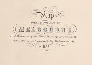
1837 Map Shewing the Site of Melbourne - Tinted
Description
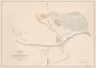
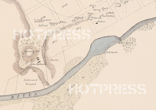
Absolutely pivotal map of early Melbourne, from 1837, surveyed and drawn by Robert Russell (with his signature in the lower right corner). We see the huts and buildings erected by the earliest pioneers, including the residences of John Batman and John Fawkner. Just to the north of the grid we see "Burial Hill", which eventually became Flagstaff Hill. A larger cemetery was established in 1838 where the Queen Victoria Market is today.
The future layout and dimensions of the town of Melbourne are clearly shown overlaying the existing buildings, most of which had to be demolished when the first land auctions (using the layout of the Hoddle Grid) were held shortly after this map was drawn in 1837. A later sketch of these auctions is shown below.
There is a degree of controversy about who actually designed Melbourne's Grid. This map apparently shows Russell's original survey of the area, which was then overlaid by Robert Hoddle to determine the streets and land parcels.
The Argus of 16th October 1934 tells the story about the layout of Melbourne's streets in 1836 thus... [1]
"On October 1 the looked-for magistrate arrived in H.M.S. Rattlesnake, the commander of which was Captain Hobson. The new magistrate was Captain Lonsdale, of the 4th or King's Own Regiment. He was followed by 30 soldiers of his regiment under Ensign King, accompanied by Robert Russell, W. Darke, and F. R. d'Arcy, surveyors.
"Russell at once began to plot out a township, running his lines for the most part through existing holdings, to the accompaniment of a chronic grumbling and discontent. A shower of petitions went to Sydney, asking for reassurance that the land sale which impended would be held, not in Sydney as rumoured, but on the spot. Bourke [Governor of New South Wales] wisely resolved to inspect Port Phillip personally, and he arrived by the Rattlesnake on March 4, 1837. His secretary (G. K. Holden), his aide (Captain King), and the new surveyor-general (Robert Hoddle) accompanied him.
"The business-like Bourke immediately mounted [his horse] without waiting to see his tent pitched, and, attended by the surveyors, picked his way among ungrubbed stumps and primeval forest along Russell's survey lines. These, which covered the area bounded by Flinders, Spencer, Lonsdale, and Spring streets, were approved, and the rough plan was handed over to Hoddle to work upon. The width of the main streets was fixed at 99 feet, instead of 66 feet as Russell had intended, and the Governor insisted on the provision of "mews" to serve the rear of the proposed allotments. These mews are the narrow east-to-west streets, such as Flinders lane, which intersect the city today."
So it appears that Russell carried out the original survey, deciding the placement of the Settlement, but Hoddle was asked to widen the streets, and to introduce the "Little" streets of Melbourne.
Compare this with the painting showing Melbourne as it was thought to be in 1836.
All text © HotPress
This is a digitally retouched reproduction of the original held by the National Library of Australia.
Our team of conservators have worked on a high resolution digital image in order to remove blemishes and artifacts such as stains, mould, scratches and damage caused by the handling of the original. We strive to provide authentic representations of the original work that are suitable for enlargements that retain the tones and character of the original.
Reference: [1] The Argus, 16th October, 1934. http://trove.nla.gov.au/ndp/del/article/10962756


