1836 Report on Disposal of Colonial Lands - Port Phillip
Description
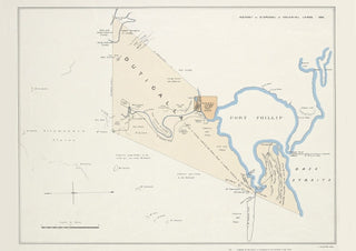
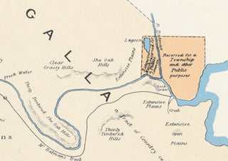
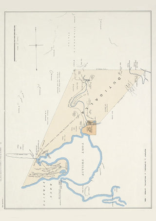
This important map shows the area of Port Phillip in 1836. (Based upon a map by John Helder Wedge - one of Batman's party - who recorded the extent of the land that Batman acquired with his Treaty.) By this time both Batman and Fawkner had established their presence on the banks of the Yarra (although at this date it is called "R. Batman" on this map, even though John Helder Wedge called it "Yarra Yarra" in 1835, mistakenly believing that that was the name given to it by the local inhabitants). It shows the route taken by Batman and his party to explore the western side of the bay, and shows just how far up the Maribyrnong river he explored.
The map was drawn with North orientated to the left. We have reorientated an image of it with North pointing upwards, to make it easier to relate it to the geographical features of Port Phillip.
The following is the description of this map from the State Library of Victoria catalogue. "Sketch of the country around Port Phillip showing Dutigalla (a tract of country ceded by the native chiefs of southern Australia to John Batman) and the area reserved for a township and other public purposes".
"Original version: [London?] : S. Arrowsmith, Lithog., [1836]. Ordered by the House of Commons to be printed 1 Augt. 1836.
Relief shown by hachures.
Title derived from publisher's catalog.
In upper right margin: Report on disposal of colonial lands-1836.
Oriented with north to the left.
Facsimile.
Publisher's no. from its catalog of nineteenth century maps of Australia from the British Parliamentary papers: 65."
This is a digitally retouched reproduction of the original held by the State Library of Victoria.
Our team of conservators have worked on a high resolution digital image in order to remove blemishes and artifacts such as stains, mould, scratches and damage caused by the handling of the original. We strive to provide authentic representations of the original work that are suitable for enlargements that retain the tones and character of the original.


