1841 Survey of The Falls
Description
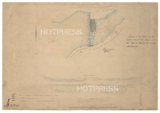
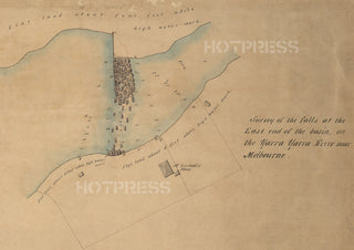
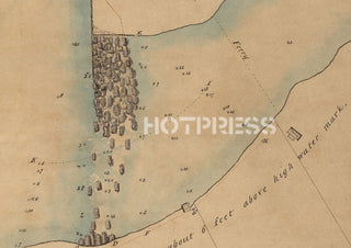
A survey of "The Falls" from 1841. The Falls were an ancient line of basalt rock that crossed the river Yarra near where Queens Bridge stands today. They were high enough to keep fresh water coming downstream separate from the sea-water that came into the river from Port Phillip Bay. The local natives used this barrier for thousands of years to gather fresh water, and to capture fresh-water fish. They also used the barrier to cross the river.
The Falls (and the freshwater that they held) were noted by the first European to visit this area, namely Charles Grimes, who was sent to survey Port Phillip Bay in 1802. Subsequently, John Batman also encountered the Falls when exploring the area in 1835. He realised that his plan for a settlement needed fresh water, and the pool of water formed by the Falls provided that essential element. However, at high tide the barrier was too low to stop the seawater from mixing with the fresh water, thereby depriving the residents of drinkable water supplies. There were a number of attempts to raise the height of the Falls to avoid the mixing of waters, but all efforts were washed away by the strong floods that regularly occurred.
The Falls, whilst they had their use, also inhibited the passage of boats upstream and downstream past that area. Flooding of the Yarra occurred quite regularly, and the Falls, even though they barely rose above the normal height of the river, impeded the flood waters.
Melbourne's water supply problem was remedied by the construction of the Yan Yean Reservoir in 1857 and the pipeline which connected the reservoir to the city. Still, the barrier had its drawbacks, and the Falls were blown up and removed in 1883 in readiness for the construction of Queens Bridge. A very small remnant of the basalt rock still exists near the southern end of Queens Bridge.
The writing in the bottom right corner says "Transmitted in letter dated 1st Febry 1841".
All text © HotPress
This is a digitally retouched reproduction of the original held by the Public Records of Victoria. All prints are reproduced without the HOTPRESS watermarks.
Our team of conservators have worked on a high resolution digital image in order to remove blemishes and artifacts such as stains, mould, scratches and damage caused by the handling of the original. We strive to provide authentic representations of the original work that are suitable for enlargements that retain the tones and character of the original.


